The Colorado River is over 2300 kilometres long and its headwaters are in the mountains of Colorado and Wyoming. The watershed for the Colorado River covers an area of over 600,000 square kilometres, including parts of Wyoming, Colorado, Utah, New Mexico, Nevada, Arizona and California, as well as the country of Mexico.
The map below (reference here) shows the upper and lower basins (watersheds for the Colorado River. Along the Colorado River and its tributaries, there are over 100 dams, including 14 along the main river itself. The river supplies water to over 30 million people and irrigates close to 4 million acres of crop land (in both the US and Mexico). Dams produce over 10 billion kilowatt-hours annually.
The map below shows the outline of the Colorado River watershed but also shown outside of the watershed boundary are large areas (red hatched areas) that rely on water from the Colorado River, including Los Angeles and areas of Colorado and New Mexico. For LA, the Colorado River aqueduct (which is nearly 400 kilometres long) diverts water from the Colorado river at the Parker Dam. There are many other diversions along the Colorado River, to the point where the river no longer flows into the Gulf of California.
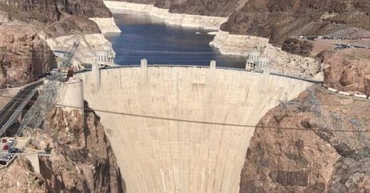
This decline in stream flow in the Colorado River is evident in Lake Mead, which was formed when the Hoover Dam was built in the 1930s and lies about 50 kilometres from Vegas. The Hoover Dam, which was the tallest dam (at over 700 feet) in the world when it was completed in 1935, was built in the Black Canyon on the Colorado River, on the border between Nevada and Arizona. Now a National Historic Landmark, the Hoover Dam was built to provide water and hydroelectric power and to control seasonal flooding of the Colorado River farther downstream. Once the dam was completed, Lake Mead began to form. At capacity, Lake Mead covers over 640 square kilometres and contains over 35 cubic kilometres of water.
The chart below (reference here) shows the history of water levels in Lake Mead. In the 1930s when the Hoover Dam was built, water levels rose to a high of over 1200 feet above sea level as Lake Mead formed. There have been fluctuations over the years but since about the year 2000, the water level has been in steady decline, to where it currently sits at under 1050 feet above sea level, the lowest level since the lake filled in the 1930s.
The next animated image (from https://earthengine.google.com/timelapse/) shows Lake Mead from the mid-1980s until 2020. Notice how the Lake has been shrinking over this period.
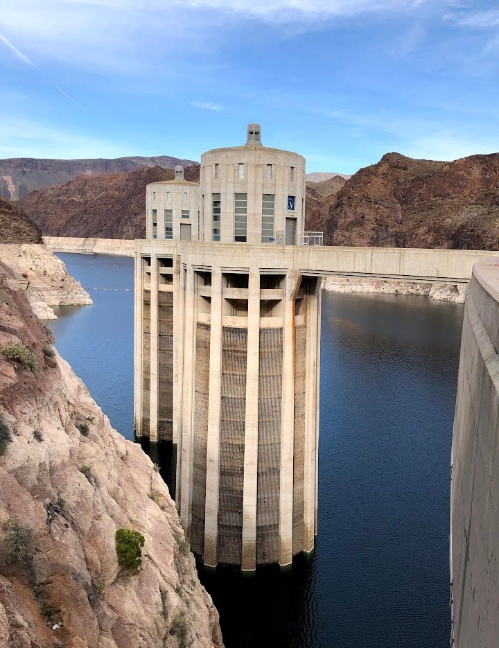
I visited the Hoover Dam in 2019. The photo below shows the water intakes on the lake side of the dam. You can see how much Lake Mead has dropped by looking at the surrounding hills. The high watermark is near the top of the white section of rock. The water level in the lake has dropped 20 to 30 feet since 2019 when this photo was taken.
There are different reasons for this decline in the level of Lake Mead:
Changes in climate. Less rain and snow leads to droughts. This can happen all over the huge watershed, including in the mountains in Colorado. Warmer temperatures also means more water evaporates back in to the atmosphere.
Population growth. As stated above, water is diverted from the Colorado River in different places. When water was diverted outside of a watershed, it can lead to droughts and water shortages. In addition to the diversion to Los Angeles, the San Juan - Chama Project diverts water from the San Juan River in the Colorado River watershed to the Rio Grand, which supplies water to places such as Santa Fe and Albuquerque in New Mexico. There are also many water diversions in the state of Colorado where water is moved from the Colorado River watershed to locations further east.
If the decline continues, it will mean less water for Las Vegas and less water for downstream users as well, not to mention a decrease in the ability of the Hoover Dam to generate electricity.
A few other interesting facts:
One of the reasons the Hoover Dam was built was to control flooding. In 1905, the Salton Sea in California was formed from a flood of the Colorado River. The Salton Sea lies in the Imperial Valley, which is a key agricultural area in California. South of the Salton Sea, Imperial Valley gets its water from the Colorado River, via the All-American Canal, which provides water for over 500,000 acres of farm land. North of the Salton Sea, Imperial Valley gets its water from the Coachella Canal.
Both the Coachella and All-American Canals get water from the Imperial Dam, which lies on the Colorado River before the river flows into Mexico. The map below shows both canals (shown as light blue lines. The All-American Canal flows east to west along the border between California and Mexico (the border is red), while the Coachella Canal flows north past the Salton Sea. (There’s a certain irony with the massive canal flowing on the USA side of the border with Mexico, adjacent to the border wall.)
The Salton Sea is of interest these days because it’s a saline water body and the minerals in this sea (and the underlying groundwater) contain dissolved lithium that might be mineable for lithium (batteries, for example). The Sea is also home to many geothermal facilities, because the brines underground are very hot.
The falling lake levels in Lake Mead have revealed “secrets” of the lake. Here’s an interesting article of what has been discovered since Lake Mead has been shrinking.
Currently at around 1050 feet above sea level, if Lake Mead drops below 900 feet above sea level, it reaches what is referred to as “dead-pool” level, where water can no longer flow downstream.
Upstream from the Hoover Dam in the town of Page, Arizona, the Glen Canyon Dam is another feature of interest. When this dam was built in the 1960s, Lake Powell formed. The water level in Lake Powell is also in decline. A good summary can be found here. The Grand Canyon lies between the Glen Canyon and Hoover dams.
There are a lot of people studying water use and water resources for the Colorado Basin. The metropolitan area of Vegas has a population of over two million. In 2022, nearly 40 million tourists travelled to Vegas. That’s a lot of people who need water for pools, lawns, fountains, golf courses, beverages. Vegas does a lot of water re-use and recycling but with continued growth, not to mention other big cities (like LA, San Diego, Phoenix) relying on water from the Colorado River, it seems inevitable that the water issues in the US southwest will only get worse. These issues will affect us in Canada. With over 450, 000 acres of farmland, Imperial Valley produces over 65 crops. Some of the food we eat is likely from this area in California that used to be a desert. Imperial Valley is dependent on the Colorado River for all of its irrigation water. The price of our food is rising and this is one of the reasons.
I’ll leave you with an article I just read on the CBC. We will be seeing more headlines like this in the near future.


Thanks, Steve! It's good to learn about this area's effects from drought and climate change. There are several other reasons for serious water volume issues in the Colorado River that I never considered. Thank you for enlightening me! Hopefully the Southwest experience will wake people up, and create good, solid, healthy change.
Good article Steve. Was in Arizona and Utah in the Fall. Continues to be high levels of growth there, particularly Utah. Going to be hard to slow the growth train, particularly in that part of the US where they really don't like rules!