


The Lake Superior Water Diversion

In one of my earlier articles, I displayed the watersheds of the Great Lakes, which represent an invaluable water resource for both Canada and the United States. Lake Superior (named gichi-gami by the Ojibwe First Nation) is the largest of the five Great Lakes and covers an area of over 80,000 square kilometres (32,000 square miles).
The watershed for Lake Superior, shown below, covers an area of over 200,000 square kilometres, and includes Nipigon to the north, as well as the cities of Duluth, Minnesota to the west and Sault Ste. Marie in the east. Water in Lake Superior flows towards Sault Ste. Marie in the southeast of the watershed, where it flows through the St. Marys River into Lake Huron.

When World War Two broke out, governments in Canada and the United States anticipated the need for more electricity. The idea that was implemented was to divert more water into the headwaters of the Great Lakes to increase the flow rate of water over Niagara Falls in order to generate more power.
By 1943, two control dams were completed to divert water into Lake Superior from two watersheds that previously had rivers that flowed towards Hudson Bay.
Let’s look at this diversion a little closer by examining the historic watersheds in the area. The map below shows the perimeter of the Lake Superior watershed prior to the diversion as a green outline. All water within that green area flows to Lake Superior and through the Great Lakes system (and over Niagara Falls). The blue outline is the watershed for the Albany River, which flows west to east and flows into Hudson Bay in the upper right of the map.

The northernmost part of the Lake Superior watershed includes Lake Nipigon, which covers nearly 5,000 square kilometres and drains into the Nipigon River, which flows into Lake Superior. In the map below, the Lake Nipigon subwatershed is shown outlined in green.

To the north and west of the Lake Nipigon watershed lies a blue outline that represents the headwaters of Ogoki River, which historically flowed into the larger Albany River. To the east, the blue outline represents the watershed for the Kenogami River and Long Lake , which also historically flowed to the northwest to the Albany River.
The Ogoki River dam was completed in 1943 and redirects water from the river into Lake Nipigon. Similarly, the Kenogami River was reversed when a dam was installed. Water was redirected from the Albany River watershed south to Lake Superior.
The result was an increase in flow of over 140 cubic metres per second (about 5,000 cubic feet per second) to Lake Superior, water that had previously flowed into Hudson Bay. It has been estimated that these diversions have resulted in an increase in the water level in Lake Superior of 2.1 centimetres.
This diversion may not seem impressive at first, but it is about 10% of the total flow that is used at Niagara to generate power, so it’s not an insignificant amount of energy. This figure (reference here) shows a summary of the diversions.
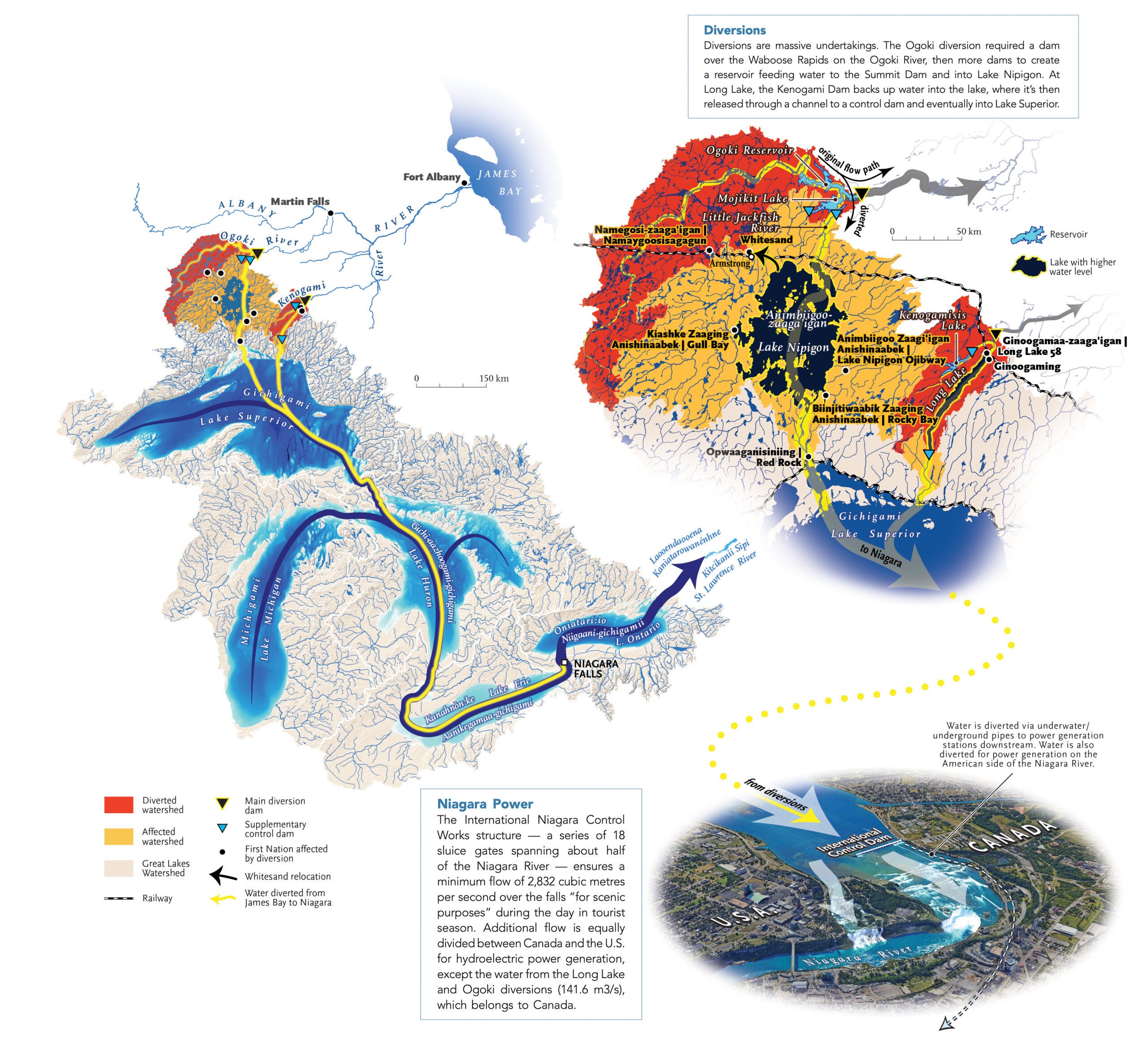
But there were side effects from these dams. Water levels and fish habitat were altered and the Whitesand First Nation, which once lived on the shore of Lake Nipigon, had to relocate due to rising water levels following the diversions. In addition, fish have become contaminated by methylmercury due to the flooding
Though these dams in Northern Ontario have been in place since the 1940s, the intrusive alterations of the Lake Superior watershed is something to think about the next time you visit the beautiful falls in Niagara.
Thanks for reading the Water Droplet! Stay tuned for more interesting articles on water. To get email notifications of new articles, subscribe here:
That's fascinating, I didn't know that. Not sure if that is a good thing bad thing. I guess bad if you are the native tribe living on the lake. Have there been any studies done on the creation of the dams, and the effects from them.
I did not know that - thanks Steve!