


Calgary and Canmore Floods of 2013
Reminders of our intimate relationship with water

I just got back from a vacation to Alberta and British Columbia where I was unable to shut off my water-curious brain. The evening we arrived in Calgary, our cell phones buzzed with an Alberta Emergency Alert (June 5, 2024). A water main break was impacting the city’s water supply and the city officials were asking residents to conserve water, with the specific instructions: “Do not shower or bath.” “Do not wash dishes, or run appliances that use water. “

We only stayed that first night in Calgary before driving to BC, so we weren’t directly affected, but three weeks later (June 26, 2024), the city continues to work on repairing the water-main break while residents and businesses follow voluntary water-use guidelines.
After a few days in BC, we drove through the Kootenay mountains, visited the Radium Hot Springs (maybe another article on these hot springs in the future?), on our way to Canmore, Alberta.
While in Canmore, I was reminded of the flooding events in Alberta back in 2013. Between June 19 and 21, 2013, over 220 millimetres of rain fell on the Cougar Creek watershed1. This watershed has headwaters in the Rocky Mountains, northeast of Canmore. The creek flows from the mountains to the southwest where it flows into the Bow River in Canmore.

In June, there was still snow in the mountains. The heavy rainfall event, combined with melting snow, resulted in a huge surge of water in Cougar Creek. Along with the high volumes of water, the creek carried debris as the fast-moving water eroded the creek channel.
Here are a couple of photos from the flood.

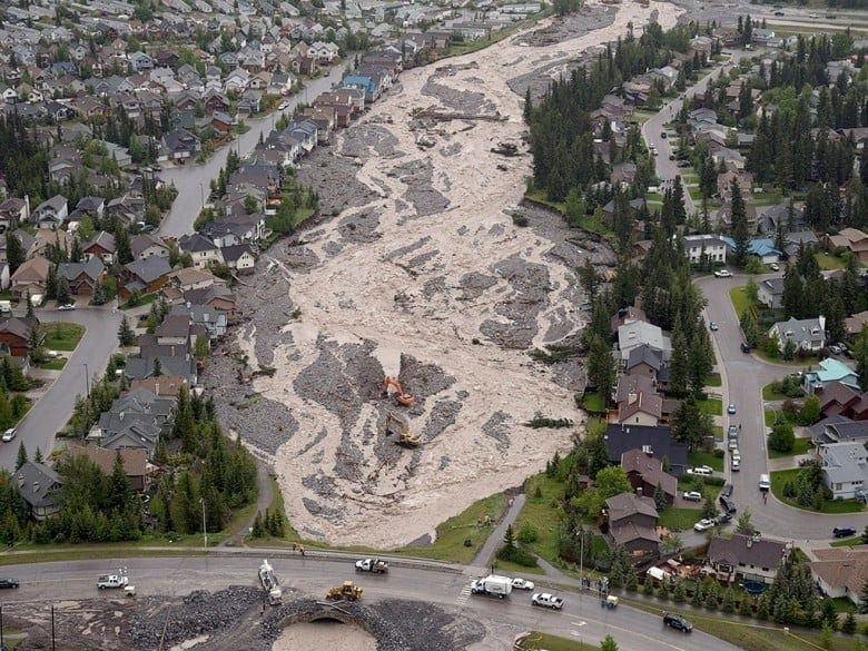
The Trans-Canada Highway was closed for 7 days and Canmore was under a boil-water advisory for 14 days. There was an estimated $30 million worth of damage to Canmore (population in 2013 was approximately 13,600).
Hydrologists study flow rates in rivers and they come up with flood-frequency analyses. For example, a one-in-10-year flood can be expected to occur every decade, while a one-in-100-year flood, which will be much more severe, is expected to occur once every century. It’s an inexact prediction, particularly with a climate that is changing, but this flood in Canmore was assessed as a one-in-300-year flood.
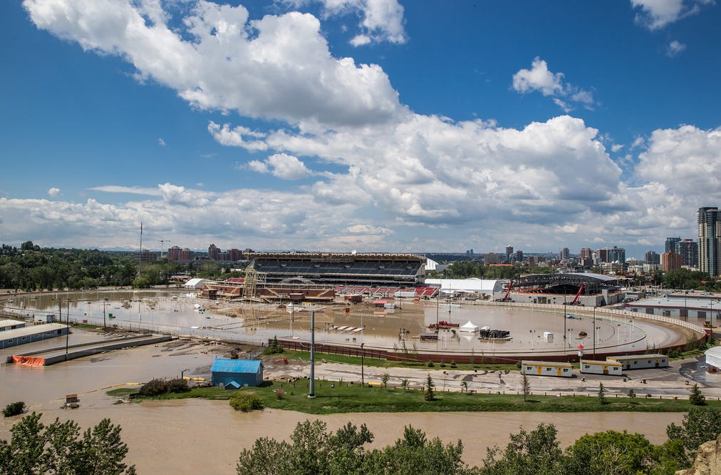
As mentioned above, Cougar Creek flows into the Bow River in Canmore. The Bow River then flows east through the foothills before entering the City of Calgary2. The rainfall event in June 2013 that drenched the Cougar Creek watershed also dumped a lot of rain onto other watersheds that feed the Bow River. One of the main tributaries of the Bow River, the Elbow River, also received large amounts of rain over the same period. All of this resulted in flow rates in the Bow and Elbow Rivers that were up to 12 times higher than normal flow in these rivers. In addition, the grounds of the Calgary Stampede lie on the floodplain where the Elbow River converges with the Bow River. As a result, Calgary suffered its worst flood in decades.
At the time (2013), I worked for an environmental consulting company that still has its corporate office in Calgary. I happened to be in Calgary only a few weeks after the floods and their office, a colleague and I looked out over the city of Calgary and could see the flooded neighbourhoods, including the grounds of the Calgary Stampede, and the Calgary Saddledome (home of Calgary’s hockey team, the Flames). Flooding inside the Saddledome covered the first 10 rows of seats!

That same flood in Calgary resulted in an estimated $5 billion in damages and claimed five lives. The flood was estimated to be a 1-in-70 year flooding event. As a result of this 2013 flood, Calgary has considered flood mitigation options that would protect the city against a 1-in-200 year flood. CBC reports that Winnipeg has flood protection for up to a 1-in-700 year flood.
It’s important to note that these flood predictions are only estimates. As global temperatures rise due to climate change, the frequency of extreme weather events is expected to increase. When we experience events such as the 2013 Alberta flood, hydrologists will ultimately re-define their flood predictions. In other words, what was a 1-in-100 year flood in the 1970s might not be the same as a 1-in-100 year flood today.
Alberta has shown resilience in its recovery from these events. I’ve only covered Canmore and Calgary, but many other communities in Alberta experienced floods from the same precipitation event in 2013. The entire community of High River (population 13,000) was evacuated on June 20, 2013. Lethbridge, Cochrane, Red Deer, and Medicine Hat also suffered damage from this event.
Our relationship with water is often overlooked and taken for granted. Either by extreme rainfall events, infrastructure (water main) failure, when our source of freshwater is compromised or when our livelihoods are damaged by floods, we are immediately reminded of how intimately connected we are with the water around us.
Thanks for reading The Water Droplet! Stay tuned for more articles on water.
The Cougar Creek watershed is 43 square kilometres. WIth rainfall of 220 millimetres, a total of over 9 million cubic metres (or 9 billion litres) of water fell in less than two days. If my math is correct, this equates to some 3,500 Olympic-sized swimming pools.
Once it passes through Calgary, the Bow River continues southeast until it converges with the South Saskatchewan River, which flows to Saskatoon before converting with the North Saskatchewan River and flowing into Hudson Bay.