


Champlain's Exploration Routes and Watersheds

Samuel de Champlain was perhaps the greatest explorer of eastern and central Canada. While this article is not meant to be a history lesson, I will track the period from 1609 to 1616, when Champlain travelled up the St. Lawrence River to the Ottawa River before making his way to Georgian Bay, Lake Simcoe and Lake Ontario.
I should preface this article by referring you to Adam Shoalts’ wonderful book “A History of Canada in Ten Maps”. In his book, Shoalts documents different European explorers who came to Canada dating back to the 15th century. I highly recommend his book, but there’s also a good online reference to this history of Canadian exploration here.
France sent Champlain to North America at the age of about 26 (around the year 1602). He was appointed as hydrographer royal by King Henry IV of France. His first voyage to Canada was 1604-1607, when he sailed to Nova Scotia, around the Bay of Fundy, south to Cape Cod before heading back to Europe.
He returned to North America in 1608, this time to the St. Lawrence River to seek routes for fur trading and he founded what is now Quebec City in July, 1608. His travels in the period from 1609 to 1616 are documented here, and presented in the map below (which is from the above link):
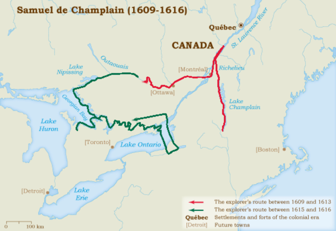
From the St. Lawrence (see the red route in the map above), he headed south on the Richelieu River (previously the Iroquois River) and would have crossed over what is now the border between Quebec and Vermont and to the present-day Lake Champlain. Samuel de Champlain allied with the indigenous groups of Huron, Algonquin and Montaignais against the Iroquois.
Champlain made his way back north to the St. Lawrence River. Convinced he was on the route to the Orient, he continued up river on the St. Lawrence (heading southwest) and turned west to head up the Ottawa River.
I generated the map below in QGIS. Champlain’s route up the Ottawa river started just west of Montreal. Champlain continued against the current, past what is now the City of Ottawa and continued to wind his way west to where the Mattawa River and the Ottawa River merge (Location #1 in the map below). The Mattawa River is still part of the Ottawa River watershed, which is shaded in red, below.
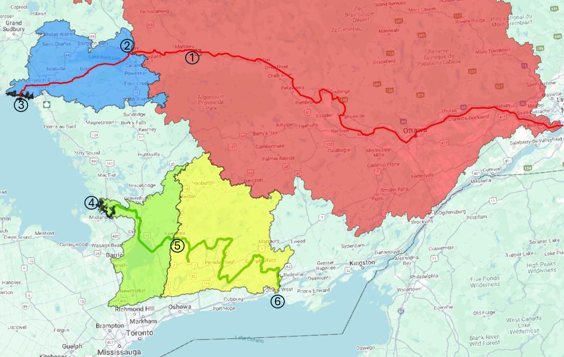
Continuing westward and upstream on the Mattawa River, Champlain would have reached present-day North Bay, where he would have crossed into the watershed for Lake Nipissing and the French River (Location #2 in the map above), shaded in blue in the above map. From there, he crossed Lake Nipissing, travelling west to where the Lake flows into the French River, which he would have continued to head west, but downstream towards Georgian Bay.
Once he reached Georgian Bay (Location #3), he sailed south and headed back inland on the Severn River at present-day Port Severn (Location #4). Here, he’d have to start heading east and upstream on the Severn River (the Severn River/Lake Simcoe watershed is shaded in light green in the map above). He could then navigate his way to Lake Couchiching and Lake Simcoe and from there, he’d continue east and cross the watershed boundary (Location #5) between the Lake Simcoe watershed and the Trent River watershed (outlined in yellow in the map above). The Trent and Severn Rivers presently contain 45 locks that allow boats to travel between Lake Ontario to Georgian Bay. But back in Champlain’s era, this river system would have been much more difficult to navigate.
Eventually, Champlain reached Lake Ontario at what is now the town of Trenton. In all, he would have passed through the Ottawa River, French River, Severn River and Trent River watersheds. He continued his journey south across Lake Ontario and into present-day New York State towards Syracuse before heading back north into Ontario. Historic details of this voyage can be found here and here.
Below is a copy of a map that was drawn in that era, with information from Champlain. After some research, I found that there is some speculation that another cartographer drew the map using information from Champlain and that it was not Champlain himself who drew the map. The area enclosed in the black box represents the Great Lakes area. Though difficult to read, the large water body, “Mer douce” is Lake Huron, while Lac St. Louis is present-day Lake Ontario. Map reference here.
Thanks for reading the Water Droplet! Stay tuned for more interesting articles on water. To get email notifications of new articles, subscribe here:
Hit “Share” below if you want to share this post!
Gracias please take a look at the Klamath watershed you painted for us gracias de nuevo
https://open.substack.com/pub/ricardoamon/p/river-of-renewal-645?utm_source=share&utm_medium=android&r=q3ow1