


The Trent-Severn Waterway

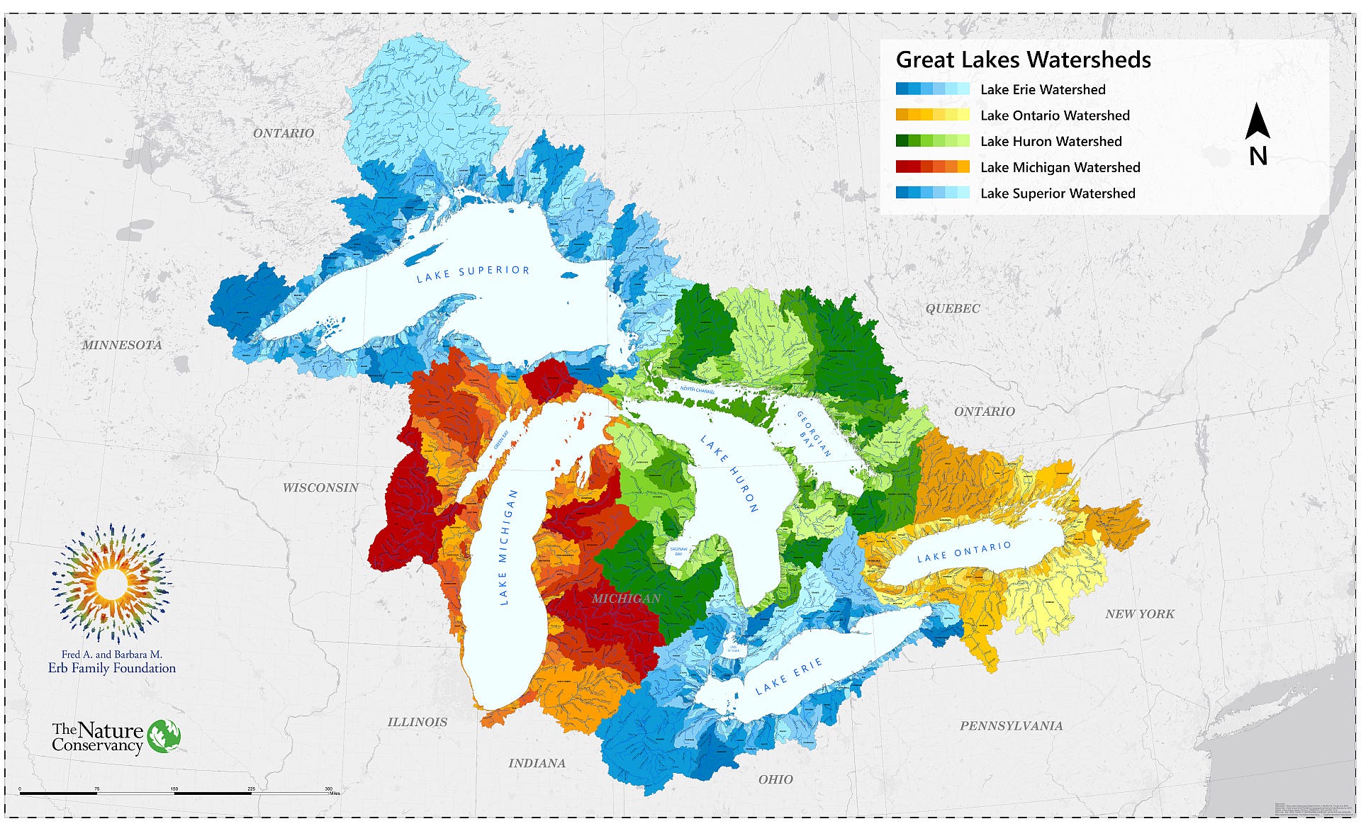
The Trent-Severn Waterway is a water route of rivers, lakes and canals that connects Lake Ontario to Georgian Bay. In an earlier article about watersheds, we learned that each of the five Great Lakes has its own watershed. This waterway crosses the watershed boundary between the Lake Ontario and Lake Huron watersheds. The map below shows the Great Lakes watersheds. The yellow colours are the watersheds of Lake Ontario and the green watersheds are for Lake Huron.
At nearly 400 kilometres in length, this waterway was built back in the 1800s and is shown in the map below

Starting at Trenton on Lake Ontario, the waterway makes its way northwest, starting with the Trent River to Rice Lake. From there, the waterway takes the Otonobee River to the Kawartha Lakes (Buckhorn, Pigeon, Sturgeon and Balsam Lakes) before reaching Lake Simcoe and Lake Couchiching where it travels through the Severn River to Georgian Bay at Port Severn.
History
The history of travel by water from Lake Ontario to Lake Huron dates back as far as the early 1600s when Samuel de Champlain travelled from Georgian Bay to the Bay of Quinte by navigating the network of inland waters between the two Great Lakes.
In the 1700s, the desire for travel between these two lakes was growing. The USA was newly formed and Canada did not exist as a nation. By the late 1700s and early 1800s, road networks were being built, including what is now Yonge Street, which starts at Lake Ontario in the south and extends north to Georgian Bay. Travel by road was slow and the need to move people and materials was growing.
It was in the 1800s when parts of the waterway were conceived and started. Locks were built to connect the Kawartha Lakes (referred to as the Back Lakes in those days, see Wikipedia). Also during this century, roads and railways were being built. Progress on the waterway went through periods of stagnation until Confederation in 1867 when the province of Ontario took control over construction. In the late 1800s, more locks were built. The federal government provided funding for more lock to be built to expand the waterway towards the western Kawartha Lakes.
However, also in the late 1800s, freight traffic moved to railways, as trains provided a better transport option. In the early 1900s, the Trent-Severn waterway was completed and while it provided efficient movement of materials to and from Lake Ontario, it didn’t have a major impact on the economy of the area. The waterway could not be used by larger boats and railway networks were growing.
By 1932, the Welland Canal was completed and the Trent-Severn waterway became obsolete for commercial purposes. The Trent-Severn waterway is still in service. It is maintained by the federal government (Parks Canada) and is used for recreational boaters.
The Locks
The numbered lock system starts near Lake Ontario. I’ve divided the 45-lock system into four groups, based on their geographic location.
Trent Region
Starting at Lake Ontario, the Trent-Severn waterway makes its way upstream at Trenton. There are 18 locks between Trenton and Rice Lake, as shown in the map below, and were built between 1907 and 1915.
Trenton lies within the Bay of Quinte and just west of Trenton, the Murray Canal (shown in yellow, below) connects the Lake Ontario with the Bay of Quinte. This canal allows ships to bypass the rougher waters of Lake Ontario to the south of Prince Edward County.
Several of these locks generate hydroelectricity and two locks are flight locks (each flight lock consists of two locks).

Kawartha Region
The Kawartha section of the waterway starts at Rice Lake and travels north along the Otonobee River to the Kawartha Lakes. Locks 19 through 27 are on the Otonabee River and were built between 1837 and 1926. Lock 21, in Peterborough, is a hydraulic lift lock and is a National Historic Site of Canada.
The remaining locks (Locks 28 to 35) connect Stoney Lake to Lovesick Lake to Buckhorn Lake to Pigeon Lake to Sturgeon Lake to Cameron Lake (not labelled) to Balsam Lake. Lock 28 (Burleigh Falls) was originally a flight lock (which is two locks). Hence, there is no longer a lock numbered 29. Lock 32 (Bobcaygeon) was the first lock built on the waterway (1830s) and has since been rebuilt twice (1850s and 1920s).

Simcoe Region
The waterway continues westward from Balsam Lake towards Lake Simcoe before heading north to Lake Couchiching. In this section, the waterway crosses over from the Trent River watershed to the Lake Simcoe watershed1. This section of the waterway includes locks 36 through 41.
Lock 36 (Kirkfield Lift Lock) is the second highest hydraulic lift lock in the world at 15 metres. This lock is also located at the highest point along the waterway at over 250 metres above sea level.
A lot of the waterway between Balsam Lake and Lake Simcoe is characterized by canals that were excavated to connect the lakes. In fact, the lake that lies between Locks 36 (Kirkfield) and 37 (Bolsover) is called Canal Lake. Note that in the map below Bolsover is incorrectly labeled as Lock #35 (it should be #37).

Severn Region
The final section of the Trent-Severn Waterway travels north out of Lake Couchiching to Sparrow Lake and follows the Severn River west to Georgian Bay. There are only four locks (42 through 45) on this section of the waterway. These locks were the final locks to be completed (1920s).
Lock 44 is the Big Chute Marine Railway (see photo below). During World War 1, construction of these Severn locks was halted. A lock was supposed to be built here, but after delays, a marine railway was built. The large trolley-like structure lifts boats from one side, across land to the other side. As designed, there’s no connection of water through this part of the waterway and as a result, this location is instrumental in halting the spread of sea lamprey from the Great Lakes to inland lakes (reference).


From Trenton to Balsam Lake the Trent-Severn waterway travels upstream. However, once the water way crosses into the Lake Simcoe watershed, the waterway travels downstream.