One of the key points from a previous article is the scale-dependence of watersheds, and how each body of water has its own watershed - from the smallest ponds and creeks to the oceans of the world. This article discusses the importance of rivers, streams and creeks.
Let’s start with some definitions. A river is a moving body of water that flows down hill by the force of gravity. For this article, I’ll use the term “streams” to encompass all types of flowing water, including: rivers, creeks, brooks. Also, let’s assume that brooks are the smallest streams, and they flow into creeks, which flow into rivers. There’s no naming convention for rivers and creeks, but typically, rivers are larger than creeks, which are larger than brooks.
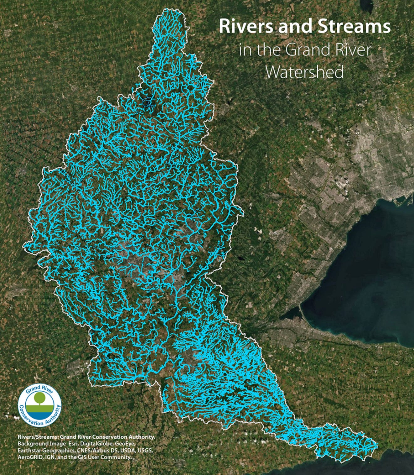
Scientists classify streams on the basis of an entire stream network, which includes smaller streams merging into bigger and bigger streams. This map is an example of a stream network from the Grand River Conservation Authority (GRCA) in southwestern Ontario. The map shows over 11,000 kilometres of streams within the Grand River watershed. All smaller streams flow into larger streams and eventually into the Grand River, which flows from the north tip of the watershed to the southern discharge point at Lake Erie.
One of the most-common methods that scientists and engineers use to classify steams is called the Strahler method, which orders streams numerically. The lowest-order streams (first order) have no tributaries (small creeks that may only be less than a metre wide). Where two first-order streams converge, a second-order stream forms, and where two second-order streams converge, a third-order stream forms and so on. In the above example, the Grand River is a seventh-order stream (for comparison, the Amazon River is 12th order and is the highest order stream in the world).
Here’s a graphical representation of the Strahler stream order (click here for reference). Note that two first-order streams makes a second-order stream, but when a first-order stream and a second order stream converge, the order remains second (i.e., 1+1=2, 1+2=2).
Stream orders 1 through 3 are often referred to as headwater streams, which are often forgotten, yet are very important. In the USA, headwater streams make up nearly 80% of all streams and these headwater streams drain over 70% of the land area (click here for reference).
In the Greater Toronto Area (GTA), the Oak Ridges Moraine is an east-west trending geologic feature of higher elevation that contains the headwater streams for rivers that drain south into Lake Ontario and north toward Lakes Simcoe and Huron. In the map below (generated at www.oakridgeswater.ca), the blue shaded area is the watershed for the upper Credit River. The Credit River flows from Orangeville in the north southward to Lake Ontario, which is off the map.
In this map below, streams are colour-coded by order. First- and second-order are red and orange, respectively. Third-order streams are yellow, fourth-order green, fifth-order blue and sixth-order streams are purple. So the Credit River starts as a third order (yellow) stream near Orangeville. As it flows south, it becomes fourth order (green) before converging with Caledon Creek (green, fourth order) which flows through Caledon Village, at which point the Credit River becomes fifth order (blue). It continues south towards Forks of the Credit, where it converges with the West Credit River (also fifth order, blue) which picks up water from Hillsborough and Erin. At Forks of the Credit, the Credit River becomes sixth order (purple), which it remains through the remainder of its journey (off the map) to Lake Ontario.
Using maps like this, it’s clear that the headwater streams (orders 1, 2 and 3; red, orange and yellow) drain a large area of land. This is important when planning activities on land - such as housing, roads, farms. Without careful planning, disruption of these headwater streams can lead to alterations in the water cycle, which in turn, can lead to issues like flooding or changes to our water resources.
When it rains, water hits the ground and flows downhill until it reaches the nearest stream (or lake or pond or wetland). All of the little headwater streams pick up a lot of water this way. However, not all of the rain flows directly to streams. Some water evaporates and some seeps into the ground and becomes groundwater. This groundwater moves through the ground and a large portion of groundwater comes back out from the ground into streams (or lakes or ponds or wetlands). At any given stream location, water flowing in the stream comes from either rain or groundwater. If it hasn’t rained in a long time, chances are most of the water flowing down a stream is from groundwater (in other words, groundwater is important!). In fact, the Oak Ridges Moraine Groundwater Program (ORMGP) has estimated that two-thirds of flow in streams comes from groundwater within their study area in south-central Ontario.
This leads to three take-home points:
Streams (and rivers and creeks) are important in the water cycle, water resources and flood protection
Streamflow rates in the big rivers depend on all the smaller streams upstream
Streamflow is highly dependent on groundwater.
This last image is an animation of a stream in the Amazon River basin. The animation covers a time period from about 1984 to 2020 (images from Google Earth). The evolution of this meandering stream shows how streams change over time. We often think of rivers as a static body of water, when in fact they are always moving and always changing.


Great article!