


The Los Angeles Aqueduct
A brief history of water supply in the city of Lost Angeles

Los Angeles, California is the second-most populous city in the United States (next to New York City). Located adjacent to the Pacific Ocean, the city of Los Angeles has a population of approximately four million residents. The city is part of the larger Los Angeles County, which has nearly 10 million residents.
To provide water for this many people, the city of Los Angeles gets water from a number of sources. The following figure (reference here), shows a water balance for the city of Los Angeles. The main water sources (shown in the upper left of the figure below) for LA are:
The California Water Project (water from the Sacramento and San Joaquin Valleys). More than half of LA’s water comes from this source.
The Colorado River Aqueduct (from Lake Havasu at the Parker Dam in Arizona). About 3% of LA’s water comes from this system.
The Los Angeles Aqueduct (from the Owens River watershed). About 30% of LA’s water comes from this system.
Groundwater. Only a few percent of LA’s water comes from groundwater.

But it wasn’t always this way. Mexican rule in this area ended in the mid-1800s, and LA was ceded to the US confirming the end of Mexican rule at the time the Mexican-American War ended in 1848. By 1850, the population of Los Angeles was a whopping 1,610 residents. In the late 1800s, railroads made their way west and by 1900, the population of LA had grown to over 100,000.
When cities grow this quickly, resources can become strained. In the early 1900s, politicians and engineers in LA realized that water supply was becoming an issue and began looking for new sources of water. A couple hundred miles east of LA, the Owens River is just under 200 miles long and lies between the eastern slope of the Sierra Nevada and the western faces of another mountain range.
Fred Eaton (mayor of LA, 1898 to 1900) and William Mulholland (appointed by Eaton as the first head of the LA Water Department, 1902) were convinced that the Owens River could provide LA with the water they needed, so the city began to purchase land in Owens Valley, without telling locals there that they were going to divert water to Los Angeles.1 The figure below shows the announcement of the Los Angeles aqueduct project in the LA Daily Times in 1905 (https://stfrancisdammemorial.org/history-of-the-los-angeles-aqueduct/?v=7516fd43adaa).

Also note that in the lower left corner, it was reported that Fred Eaton misled locals in Owens Valley. They were under the impression that Eaton was preparing to go into the stock-raising business. When the locals later learned that water from Owens Valley was being diverted to LA, they were incensed.2 The Los Angeles Aqueduct was completed in 1913 and by 1930, the population of LA was over 1.2 million. The completed aqueduct was over 230 miles long. The following figure can be found here: https://53f235.p3cdn1.secureserver.net/wp-content/uploads/2019/10/LA-Times-Nov-6-1913-1-719x1024.png

The Los Angeles Aqueduct has allowed the growth of the city of Los Angeles to become what it is today (for better or worse). The effects of the Los Angeles Aqueduct, however, have been occurring in the 100+ years since the aqueduct was built.
One side effect of the aqueduct was the St. Francis Dam disaster in the 1920s. This dam was built,3 as an integral part of the Los Angeles Aqueduct. Located in the San Francisquito Canyon, 40 miles from Los Angeles, the St. Francis Dam was built to create a reservoir to store water for LA in the event of a drought and to generate hydroelectric power. Upon completion in 1926, the St. Francis Dam was allowed to fill to capacity and in March 1928, the reservoir behind the dam was completely filled. Upon inspection, the dam keeper discovered a leak in the dam and alerted William Mulholland, who designed the dam. Mulholland conducted an inspection and concluded that the new leak posed no threat. Five days later, the St. Francis dam failed. Residents downstream from the dam were killed as the flood wave, as high as 120 feet, raced down the valley at nearly 18 miles per hour (28 km/h). Official records show that 385 people died as a result of the failure of the St. Frances Dam. William Mulholland, who was instrumental in the creation of the Los Angeles Aqueduct, was held responsible for the dam’s failure. He resigned in 1928 and died from a stroke in 1935 at the age of 79.
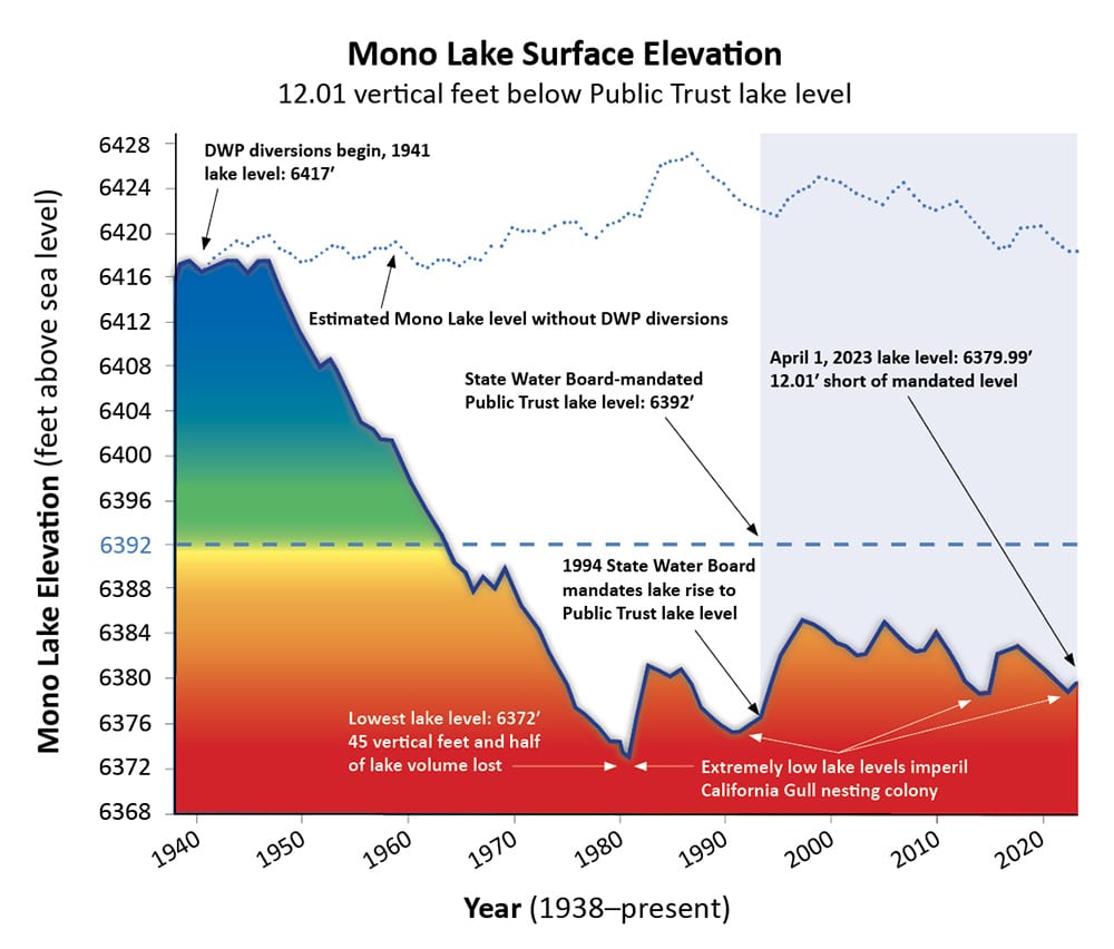
In 1930, LA needed even more water and the Mono Lake Extension Project was initiated. This project extended the Los Angeles Aqueduct over 100 miles north of Owens Lake. Although the water in Mono Lake is too salty to drink4 (two-to-three times saltier than the ocean), it supports brine shrimp, which provide a food supply to migrating birds. The diversion of water from the freshwater tributaries that fed into Mono Lake has resulted in a water level drop in the lake of 45 feet by the 1980s. Court orders required LA’s Department of Water and Power (DWP) to reduce the city’s water takings from this area to about 1/3. The water level in Mono Lake has recovered but levels are still some 20 to 30 feet below pre-LA-diversion levels.

A second LA aqueduct was built between 1965 and 1970 so that LA could take full advantage of its water permits for Owens Valley. An additional 50% capacity was added to the system with the second aqueduct.

Another side effect of the Los Angeles Aqueduct is air pollution. Because of water diversions for the aqueduct, the lake bed of Owens Lake has been dry since the 1920s. This has exposed minerals and salts to the atmosphere. Dust storms through Owens Valley eroded the minerals and salts, which were picked up by the wind. This resulted in air pollution from the eroded dust. In the last two decades, under court order, has spent over two billion dollars to introduce vegetation and shallow flooding to Owens Lake in an effort to reduce dust. This has resulted in the return of thousands of migratory birds to the area.
The evolution of cities usually takes place near readily-available sources of fresh water. Toronto is located on Lake Ontario. Chicago is on Lake Michigan. New York City gets most of its water from the watersheds along the Hudson River. The water supply for Los Angeles, however, is a different story.
The history of the population growth of the city of Los Angeles is incomplete without a history of the city’s water supply. Two hundred years ago, the Los Angeles River provided enough water for the city. However, the Pacific Ocean and the Mediterranean-like climate made LA an attractive location for Americans who migrated from the east. The demand for water rose with the growth of population and the city had to look for new water sources. Today, LA gets its water from all over the state of California (as well as Arizona), but these water takings are not without consequence. While LA is trying to address the issues that have been caused by their water takings, is it just a matter of time before they need water from even farther away?5
Thanks for reading The Water Droplet and keep watching for more stories about water!
Recommended references:
History of the Los Angeles Aqueduct: https://www.ladwp.com/ladwp/faces/ladwp/aboutus/a-water/a-w-losangelesaqueduct?_adf.ctrl-state=1uzcxgntf_4&_afrLoop=631962102521906
Slideshow about the Los Angeles Aqueduct: https://www.slideshare.net/MavensManor/the-los-angeles-aqueduct-slideshow
Exploring the ruins of the St. Francis Dam: https://www.atlasobscura.com/articles/notes-from-the-field-exploring-what-remains-of-st-francis-dam
Water and Power Associates (non-profit organization with a mission to inform the public about water and energy issues in LA and California): https://waterandpower.org/museum/museum.html
Cadillac Desert: The American West and Its Disappearing Water (1993): https://www.amazon.com/Cadillac-Desert-American-Disappearing-Revised/dp/0140178244
Chinatown (1974 film, inspired by the California water wars): https://www.imdb.com/title/tt0071315/
These links provide further details of the history of the Los Angeles Aqueduct:
In 1924, ranchers in Owens Valley were worried about the valley’s future. They waged a water war and dynamited the aqueduct 17 times to try to prevent water from flowing south to Los Angeles.
A detailed timeline of the failure of the St. Francis Dam can be found here: https://stfrancisdammemorial.org/timeline-of-the-st-francis-dam-disaster-and-los-angeles-aqueduct/?v=3e8d115eb4b3
Mono Lake is in a closed basin. The tributaries that flow into the lake are freshwater, but the lake has no natural outflows, so water can only exit the lake by evaporation. When the water evaporates, salt is left behind, thereby increasing the salinity of the lake.
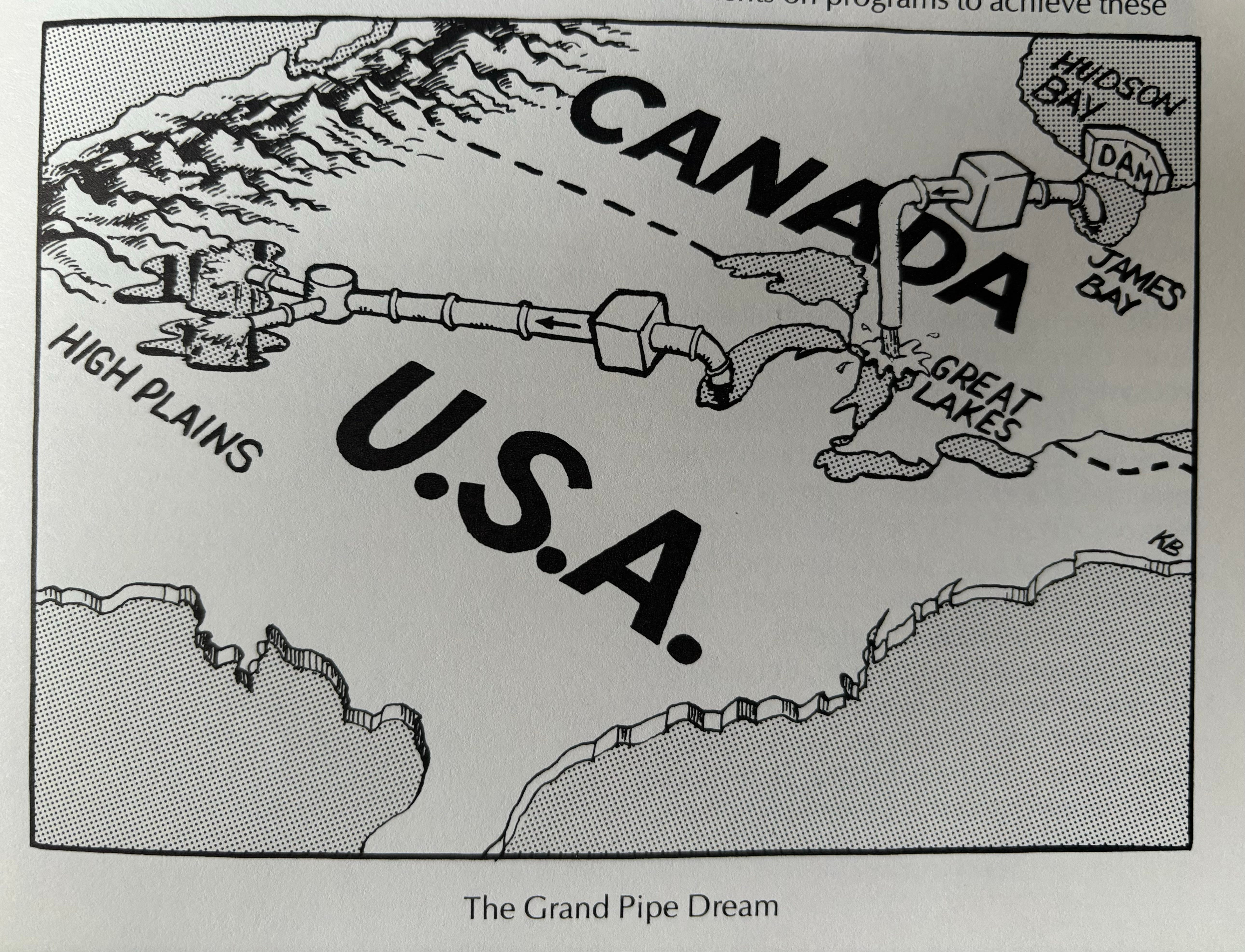
The Columbia River in the Pacific Northwest has been on southern California’s radar for a while. There’s also been talk for decades about moving water from the Mississippi River to the American southwest. There has even been talk about water from the Great Lakes being piped to the southwest. (Note the following cartoon is from “The Great Lakes Primer, written and published by Pollution Probe, 1986.)
Thanks for the read, Steve. As a former resident of CA (albeit the San Francisco Bay Area) I was aware of LA's water history to some extent, but your post filled in more detail. I also remember biking across Yosemite to Lee Vining (and Mono Lake) in the mid 1980's.
Cheers, Jun Nogami