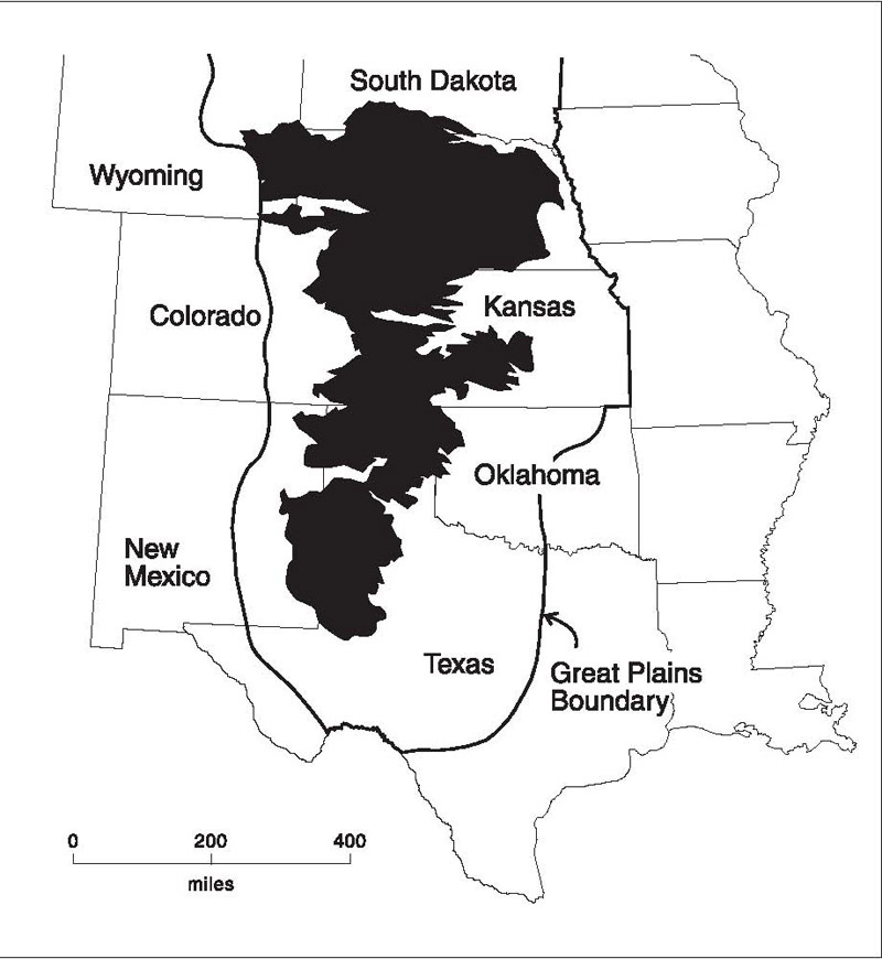
The Ogallala Aquifer (see map below) underlies parts of eight states (South Dakota, Wyoming, Nebraska, Colorado, Kansas, New Mexico, Texas and Oklahoma) in the US-Midwest. One source (linked here) states that the Ogallala aquifer holds (or has held) enough water to cover all 50 states in about 18 inches of water (the equivalent of one quadrillion gallons, or three billion acre-feet,1 or the approximate estimated volume of Lake Huron).

This aquifer has provided water for agriculture and communities in the region for decades. However, due to overpumping, groundwater levels in the Ogallala Aquifer have declined to the point where wells have run dry.
The Ogallala Aquifer (sometimes referred to as the High Plains Aquifer2), underlies approximately 174,000 square miles. Nearly 200,000 irrigation wells have extracted groundwater from this aquifer since the 1940s and groundwater levels have declined by as much as 200 feet3 as a result of overpumping4.
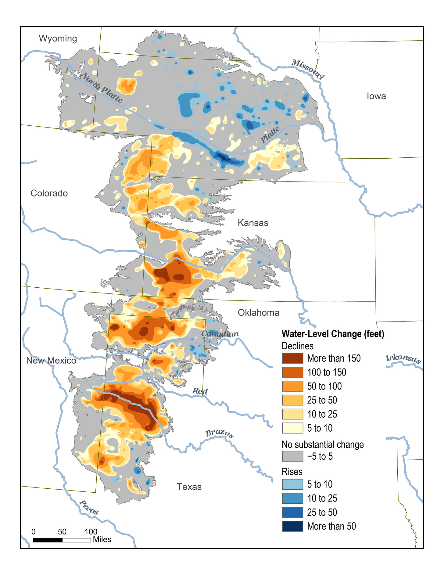
The following map shows the changes in groundwater levels in the Ogallala Aquifer from predevelopment (circa 1940s) until 2015. The warmer colours show declines in water levels on the order of 200 feet in Kansas, Oklahoma and Texas. Grey areas indicate no significant change in groundwater levels and blue areas (mostly in Nebraska) indicate an increase in groundwater levels since predevelopment.

To understand this issue, we need to look at the water balance for the Ogallala Aquifer. In other words, how much water is being taken from the aquifer and how much is being replenished5.
Irrigation is the main activity that removes water from aquifer (for mainly corn, alfalfa, soybeans, wheat sorghum, and cotton). Many crops support the cattle and dairy industry. The United States Geological Society (USGS) reported that in 2015, the High Plains aquifer was pumped at approximately 12,300 million gallons per day (or about 4.5 trilllion gallons per year). Another references reports that 19.6 million acre-feet were pumped in 2005 (about 6 trillions gallons per year)6.
The estimated total volume of water of 1 quadrillion gallons divided by 4.5 trillion gallons per year (whic is the estimated withdrawal rate) is about 200 years worth of water, based on 2015 estimated pumping rates.
Today, most of the recharge to the Ogallala comes from rainfall and snowmelt. The rate of this recharge is very slow (less than one inch in a year7). See the footnotes for some math, but this recharge rate is equivalent to approximately three trillion gallons of recharge water per year. By my very rough estimates, this means that water users are pumping at a rate that is 1.5 to 2 times higher than the recharge rate. This estimate is similar to one report, which states that current pumping exceeds recharge by about three times.
This overpumping is the cause of the decline in water levels of the High Plains, or Ogallala Aquifer.
The state regulators have some loose rules in place, and these rules vary state-to-state. For example, In Kansas, Colorado, and Texas, where groundwater levels have high declines, irrigators have the right to pump far more water than the aquifer can sustain. In some areas, water use is prioritized to those who have been there the longest. Sometimes, regulators are reluctant to place limits on irrigation because agriculture is an important business and some states allow the groundwater levels to decline because of the economic benefits of irrigation.
So what can be done? Water needs to be managed better. Researchers and governments are looking at ways to improve the efficiency of irrigation systems. When land is irrigated, a lot of the irrigation water is lost to evaporation or deep percolation.8 Higher efficiency systems minimize this loss, thereby allowing less water use. These more efficient systems allow operators to use older groundwater wells that could no longer sustain previous water usage.
Data collection is invaluable. We need to understand how much water is being used and for what purpose. This will allow scientists and engineers to understand the aquifer better, and to make more accurate future predictions of aquifer conditions.
Whether or not the Ogallala Aquifer can rebound remains to be seen. Wells are already running dry and this trend will continue. Sustainable water-use practices can help, but it may be too little too late.
Thanks for reading The Water Droplet and keep watching for more stories about water!
One acre-foot is the volume of water that would cover one acre of land with water that is one foot deep. One acre-foot is equal to approximately 1,233 cubic metres, or 1.233 million litres.
Some researchers state that the Ogallala Aquifer is part of the larger High Plains Aquifer, but others use the two interchangeably.
The Ogallala Aquifer is in the USA and as a result, the references I’ve used are American. Since the USA uses imperial units, I’ve reported the data directly from the references rather than covert to metric units.
I use the term ‘overpumping’ to describe the practice where groundwater is pumped from the ground a rate that exceeds the rate at which the groundwater is replenished by recharge.
In the water world, we often refer to activities that remove water as “sinks”, and activities that add water as “sources”.
If we use the estimate of 1 quadrillion gallons of water for the total volume of water in the Ogallala aquifer and we use an annual pumping rate of 5 trillion gallons per year, we end up with a time of 200 years before the aquifer is completely dry. This is a very simplified estimate and there are many more factors that come in to play.
One inch per year over the entire area of the Ogallala Aquifer (174,000 square miles) converts to about three trillion gallons of water recharged. However, The recharge rate across the area is highly variable, with some places getting as much as two inches per year and other places getting one-tenth of an inch per year. Recharge is also highly variable over time. With increased drought, some areas will get very little or no recharge at all in drought years.
Deep percolation occurs when water applied to crops infiltrates deeper than the roots of the plants.


