


Water Levels in the Great Lakes

The Laurentian Great Lakes lie on the boundary between Canada and the United States. The five lakes (Superior, Huron, Michigan, Erie, Ontario) cover nearly 250,000 square kilometres (approximately 95,000 square miles) and the total drainage is over 500,000 square kilometres (about 200,000 square miles). The map below shows the five Great Lakes and the drainage area (watersheds) for each lake (reference here). The Great Lakes are part of the larger watershed for the Atlantic Ocean; all water within the Great Lakes watersheds eventually flows through the St. Lawrence River to the Atlantic.1

To understand how water levels in the Great Lakes behave, it’s important to have an idea of the water balance. If we look at Lake Superior in the north, all precipitation that falls within the watershed (on the lake itself or on the surrounding land within the watershed) either evaporates up into the atmosphere or remains within the Great Lakes system until eventually flowing to Lake Huron through the St. Marys River. From Lake Huron, water flows south towards the St. Clair River (near Sarnia, Ontario), through Lake St. Clair and the Detroit River before entering Lake Erie. From Erie, water flows to the east before going into Lake Ontario at Niagara Falls. From Lake Ontario, water flows through the St. Lawrence River and into the Atlantic Ocean.2
Of the five Great Lakes, Lake Superior is the largest and deepest. It is also the farthest from the Atlantic Ocean. The following figure (reference here) shows the depth and water-surface elevation of each Great Lake as water moves from uphill (Lake Superior) to the ocean.
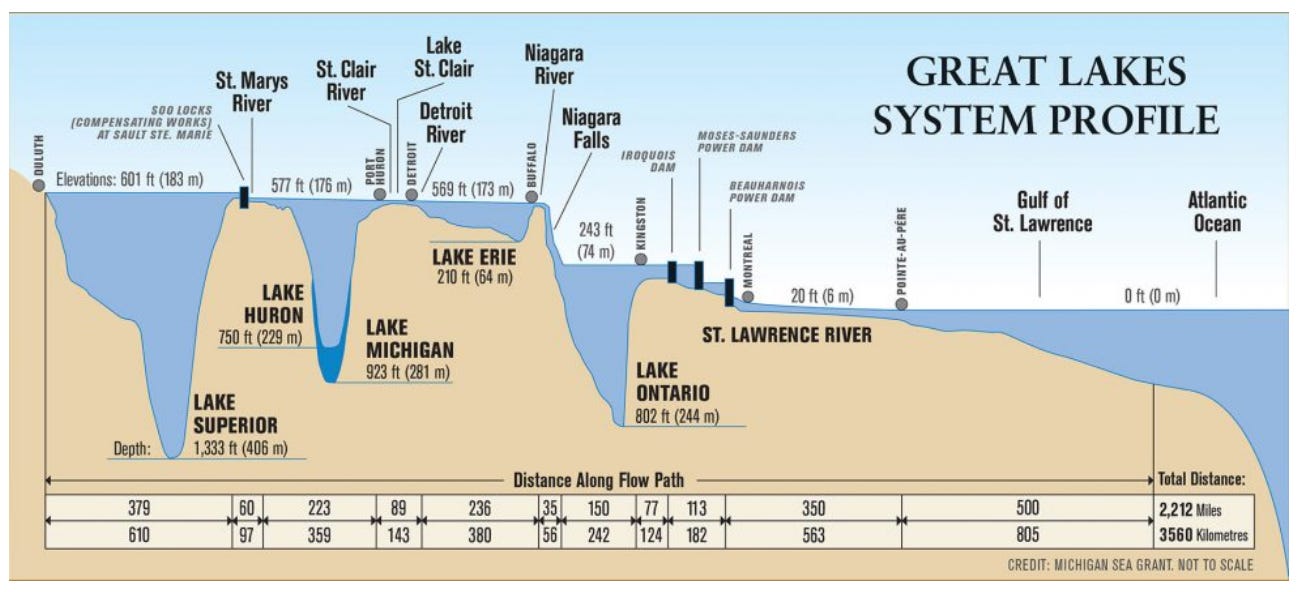
There are a couple of interesting observations in this figure:
Lake Huron and Lake Michigan are drawn on top of each other. These two lakes are essentially one big lake separated by a narrow strait in the USA. The water level in these two lakes is, on average, the same.
Lake Erie is very shallow in comparison to the other four lakes. At a maximum depth of under 70 metres, Erie is over 300 metres shallower than the deepest lake, Lake Superior.
The biggest drop in water level occurs at Niagara Falls, where Lake Erie flows into Lake Ontario.
On average, a droplet of water takes over 173 years to pass through Lake Superior, while that same droplet of water takes over 200 years to pass through the entire Great Lakes system into the Atlantic Ocean.3 It’s important to remember that each lake gets its water from different sources. Lake Ontario, for example, gets a lot of water from Lake Erie (via Niagara Falls and the Welland Canal). In addition to that, Lake Ontario gets water from the many other rivers from both the Canadian and American shores.
Water Levels of the Great Lakes
Both the Canadian and American governments have been monitoring water levels in the Great Lakes since the early 1900s. The figure below shows the mean monthly water level in each lake since 1918 (note: Lakes Michigan and Huron are reported as one).
The water level in any of the lakes varies over the course of each year. As winter turns to spring, snow and ice melt and a surge of water is released into the lakes from rivers with each watershed. This leads to a higher water level in spring. In summer and into fall, precipitation tends to decrease and lake levels drop heading into the winter.
But there are longer-term trends as well. On the figure below, Lake Michigan-Huron shows higher water levels in 1929, 1952, the early 1970s, mid-1980s, late 1990s and early 2020s. Lake Erie follows a similar long-term trend.

There are several factors that could be influencing the water levels in the Great Lakes:
Climate: Warmer temperatures lead to less ice on the lakes in winter, which leads to more evaporation, thereby decreasing lake levels. However, more evaporation can lead to more precipitation, which can increase lake levels. Climate scientists have been looking at long term trends in lake levels (and lake temperature) to see if there are any indicators for climate change.
Weather: Shorter term weather events can have an effect on lake levels. In July 2013, Southern Ontario had a flash flood, with over 10 centimetres of rain falling in two hours. The City of Toronto experienced major flooding issues. In winter 2018-19, precipitation and thawing events resulted in flooding in different areas of Lake Ontario. Montreal was also affected, as were communities along the Ottawa River.
Land use: As population grows, how we use our land changes. For example, when we pave over land that was previously forested or farmed, we are redirecting water that once infiltrated the ground directly into streams. This can affect the water balance.
Dams. Between Lake Ontario and the Atlantic Ocean, flow of water is controlled by dams along the St. Lawrence River. These dams control the water level in Lake Ontario as well as the water levels in the St. Lawrence River. If water levels in Lake Ontario are high, more water can be released into the St. Lawrence River; however, if too much water is released from Lake Ontario, flooding can occur in Montreal (particularly if flow in the Ottawa River is exceptionally high).4
Those of us who are fortunate enough to live in the Great Lakes watershed have never had to worry about water supply. However, we cannot become complacent. We need to continue to understand our water systems. With our climate changing, we will likely experience more extreme weather conditions, which could lead to issues that affect our water (for example, flooding or contamination of water supply).
Thanks for reading The Water Droplet and keep watching for more stories about water!
There are several diversions of water into and out of the Great Lakes Watershed. More information can be found here.
Lake Michigan water flows into Lake Huron.
These estimates of travel time vary. One reference lists a water residence time of 173 years for Lake Superior, and another reference reports 191 years for Lake Superior. Estimates for the travel time to get through the entire Great Lakes system from the same two references are 204 years and 321 years, respectively.
One reference states that lowering the water level in Lake Ontario would result in an increase in the water level in Montreal by 12 inches.