In a previous article, I wrote about the water cycle, which describes how water moves through the world. Most components of the water cycle are easy to see: rain, clouds, lakes, rivers etc. Groundwater, however, is somewhat of a mystery.
In 2022, the United Nations Educational, Scientific and Cultural Organization (UNESCO) released a report on groundwater titled “Groundwater: Making the invisible visible”. The problem is: groundwater is never visible; if we see water seeping out of a hill slope, it’s no longer groundwater. Or if we pump water from a well, once it comes up the well, it’s no longer groundwater.
How can something so invisible be so important? Here are some key points from the UNESCO report:
99% of all liquid freshwater in the world is groundwater
About half of all domestic water used in the world is from groundwater, particularly in rural areas that are not connected to public water supply systems
Groundwater is important in the fight against poverty
Groundwater is key in water and food security
Groundwater is often poorly understood, undervalued, mismanaged, abused
What is Groundwater?
Simply put, groundwater is water underground. Imagine a bucket full of sand and then imagine pouring water into the bucket. The water will disappear into the sand, becoming groundwater.
In some places, you don’t have to dig very far to find groundwater. In other places, you won’t find groundwater for hundreds of metres or more.
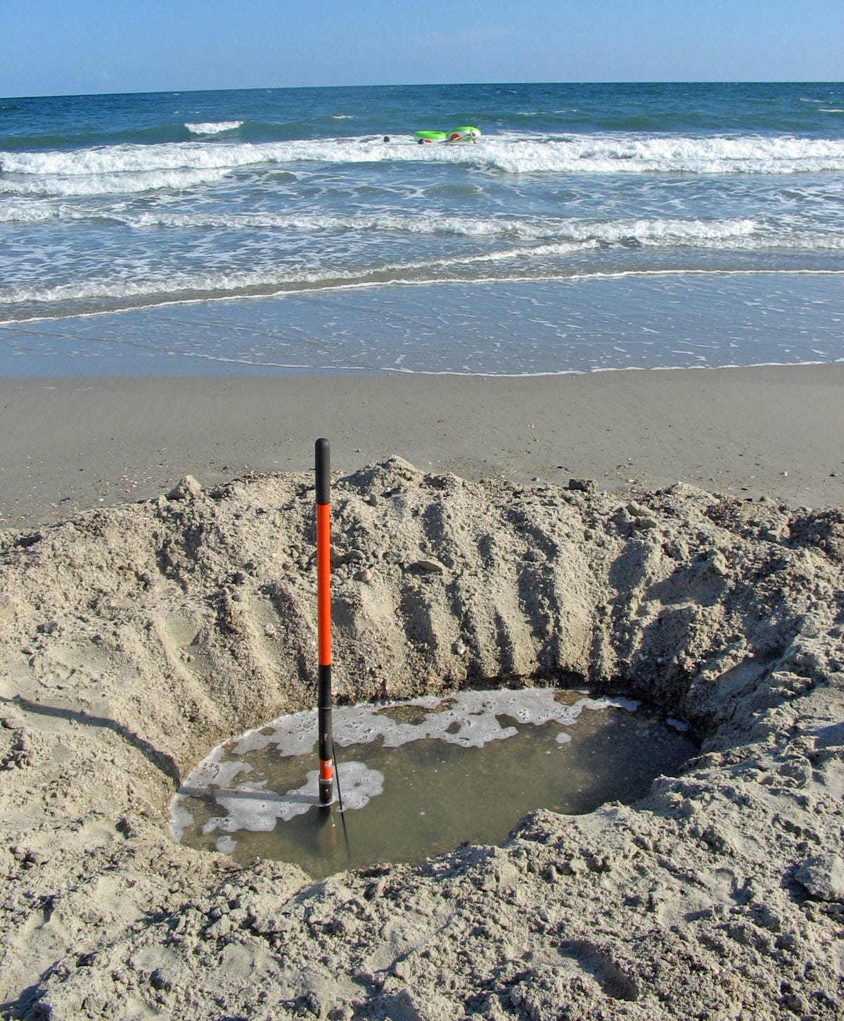
Groundwater exists in the geologic material beneath our feet: in the space between grains of sand or in cracks in solid rock, for example. If you dig a hole in the sand on a beach, you’ll likely reach water without having to dig very deep. The photo below is from the United States Geological Survey (USGS)
In this photo, groundwater has seeped into the hole. When groundwater is close to the ground like this, the groundwater level is referred to as the water table, which can be thought of as the water level underground.
The nature of the geologic materials plays a key role in how groundwater moves through the ground. Sand and gravel can store enormous volumes1 of groundwater and groundwater can flow readily (Note: groundwater flow rates are much lower than in streams. Streams can flow many kilometres in a day, whereas a “fast” groundwater flow in sand and gravel might be a few metres in a day2). Any geologic material that can transmit significant quantities of groundwater are typically referred to as an aquifer. Aquifers can represent huge water sources. In Ontario, Kitchener-Waterloo (population: over 450,000) relies on groundwater from sandy aquifers for about 75% of its water, and the city of Guelph (population: 135,000) relies 100% on groundwater from limestone/dolomite aquifers3.
Other geologic materials can act as barriers to groundwater flow. Clay, for example, might have groundwater flow rates on the order of millimetres per year4. Geologic units like this that inhibit groundwater flow are referred to as aquitards.
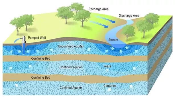
A 3D block of earth is drawn in the image below (reference here). In this diagram, water enters the ground in the recharge area5. The uppermost aquifer is unconfined because there is no confining bed (aquitard) above it. In these unconfined aquifers, you’ll find the water table. The lower two aquifers are confined by overlying aquitard units. Note the relative groundwater ages in the confined aquifers. Deeper aquifers may store groundwater that has been underground for decades or even centuries.
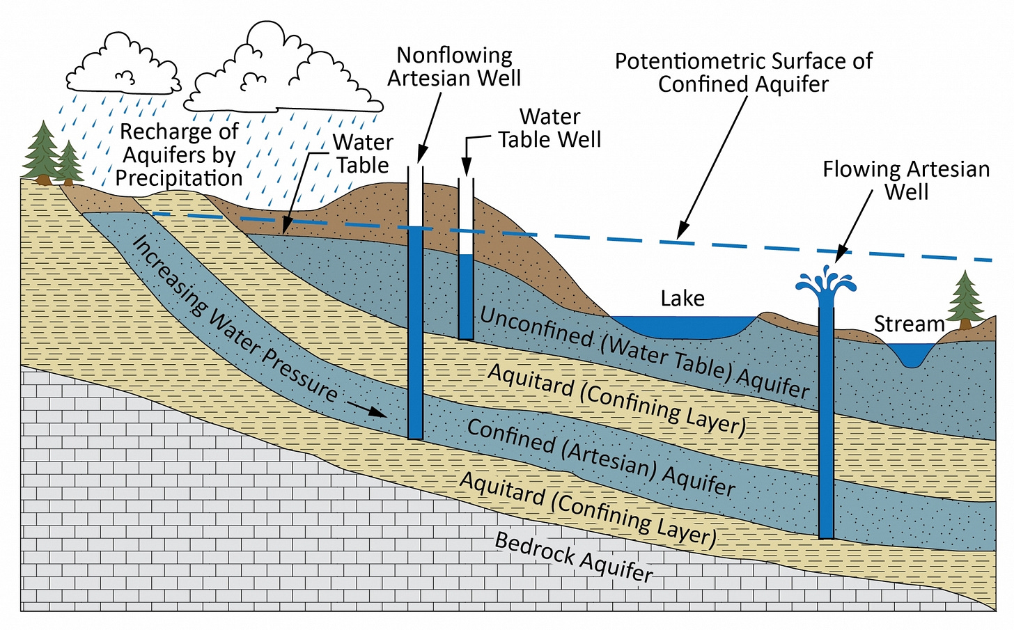
But this diagram is just a local-scale representation. Deeper aquifers might get recharged from areas farther away. For example, see the next image (reference here). In this image, a vertical slice (or cross section) of earth is shown. The confined aquifer is recharged from areas farther away. This can result in an increase in water pressure in the deeper aquifer. A water well between the lake and stream is a flowing artesian well. This is in contrast to the water-table well and non-flowing well to the left.
The water levels in the three wells in the diagram below are shown in dark blue. Groundwater flows from high pressure to low pressure, and these water levels indicate the water pressures at specific locations underground. In this example, water pressures are higher in the confined (artesian) aquifer than in the unconfined aquifer.
So we can see two groundwater flow systems here. In the unconfined aquifer, groundwater flows from where the water table is high to where it is low. Near the lake, shallow groundwater flows into the lake (same with the stream). In the confined aquifer, groundwater flows from high pressure to low pressure, and the distribution of pressure in this deeper aquifer is show by the dashed line, which shows the potentiometric surface. In this deeper aquifer, groundwater is flowing left to right.
Understanding groundwater requires more than studying what is happening on a local scale (i.e., close to a pumping well). It’s very important to understand where the groundwater is being recharged. Changes in activities on land (e.g., converting farm land to urban development) can have effects on water resources far away. Groundwater plays a huge role in all of this and should always be taken into consideration for all activities on the ground surface.
In beach sand, the pore space between the grains of sand represents about 30 to 40% of the total volume. Think back to that bucket of sand: if you fill a one-litre bucket with beach sand followed by water, you’ll have a full bucket that includes about 0.3 to 0.4 litres of water. The ratio of void space to total volume is called porosity. In this example, the porosity of beach sand is 30 to 40%.
Groundwater flow rates are dependent on the nature of the geologic materials as well as the hydraulic gradient, which is the change in pressure from one location to another. This hydraulic gradient is conceptually similar to the gradient of a stream: water will flow faster on steeper slopes.
Bedrock aquifers can occur when rock has cracks and other openings to store groundwater. This is the case in Guelph. Some bedrock materials, however, are highly impermeable to the movement of groundwater and are poor aquifers but good aquitards.
Clay materials have unique properties in that they can store a large volume of water, but water moves very slowly through clay.
When rain falls to the ground, some of it evaporates, some is taken up by plants (transpiration) and some runs down hill to ponds, streams etc. The remaining water will seep into the ground as recharge. The rate of recharge is highly variable and it depends on the nature of the materials in the ground. Typical rates of recharge might be around 25% of precipitation.


Again - informative.
Question and maybe a 'stupid' one but it is stated that " 99% of all liquid freshwater in the world is groundwater." I question how much of earth's water is 'fresh' when there is so much pollution.. Is the groundwater not mostly fresh or as I interpret fresh, clean?
Helen